<<--- Go back to quick links to Eisenhower Parkway Extension  -   - Macon, Georgia  , USA  - -

16_to_80        - a new optional route  -     "16-2-80"

formulated by Citizens who want Better Options

I-16 is re-aligned away from the Ocmulgee National Monument's main unit.

I-16 is reconnected to I-75 at US-80.

Win - Win - Win  .. ???

Advantages:

Gives all sides what they need. A New East-West connector with LESS Environmental/Cultural impact than the current existing roads.

Mitigations

1- i-16 berm would be removed from ONM.

2- restore hydrodynamics at ONM

3- restore connection of Great Temple Mound to the Ocmulgee River

4- precludes lighting of i-16 in ONM

5- reduces noise in ONM

i-16 and i-75

6- reduces disruption and the size needed for planned intersection improvements

Greenway

7- more options for trails - it could restore the old river road which is visible in historic pics of ONM before 1970.

Flooding

8- Macon may never need to flood again at Riverside Dr, Pierce Ave, Spring Street Bridge, Otis Redding Bridge

9- there would be no new diamond interchange in the floodway

10- pressure on levee would be reduced {or else remove the levee as well}

Wildlife corridor improvements

11- It would better permit the migration of ground dwelling species to migrate from the Bond Swamp Refuge into the ONM. Currently those species are blocked by the fencing along and the berm beneath i-16

Cost

12 - comparable to [may be much less than] a- EPE + b- New Interchange EPE/i16 in the middle of Ocmulgee Floodway, + c- 6 new bridges planned to fix the existing defective intersection of i75 with i16 [which is also located in the Ocmulgee Floodway.]

13 - would be carried by almost all federal money since it is a Re-alignment of a defective piece of interstate highway system. [the i16 berm within the ONM is the single largest man-made factor in the flooding of Macon in 1992 and 1994 and the failure of the levee]

Archeology

14- New road would be elevated .  Not on pilings.   Each concrete column would be poured into an [Archeologically ] excavated casing.  

15- Oversight by Native American NAGRA representatives and an Archeologist at each site.  

16- University would be resposible for timely reports and summaries of findings.

Traditional Cultural Properties

17- Purchase these lands for preservation..

18- A new Muscogee-Creek Native Studies Institute.

Road Builders

19- will still be able to build a fairly expensive highway, with opportunities for world class creativity and designs.

Problems with the DOT "prefered route" has always been drawn through the legislated boundaries of the Ocmulgee National Monument.

EPE - Proposed Route

The Georgia Department of Transportation used to consider this a section of what is commonly referred to as the Fall Line Freeway.  

 Ocmulgee National Monument near Macon put on most-threatened parks list

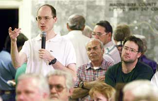
By CHRISTOPHER QUINN

Atlanta Journal-Constitution Staff Writer

[ The Atlanta Journal-Constitution: 3/26/02 ]

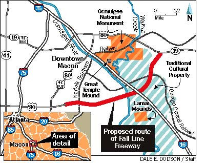
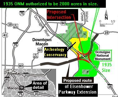
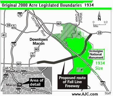
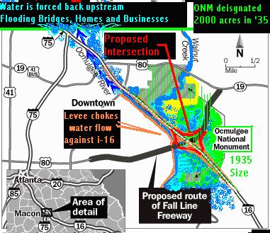
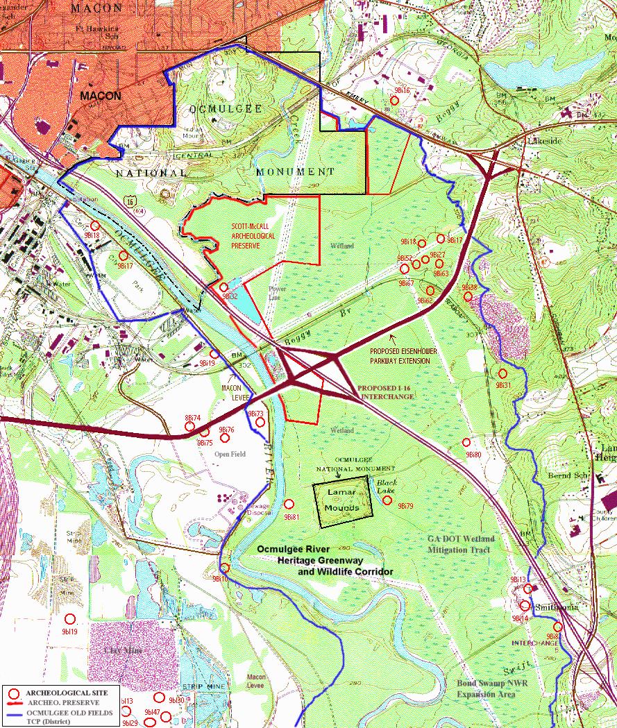
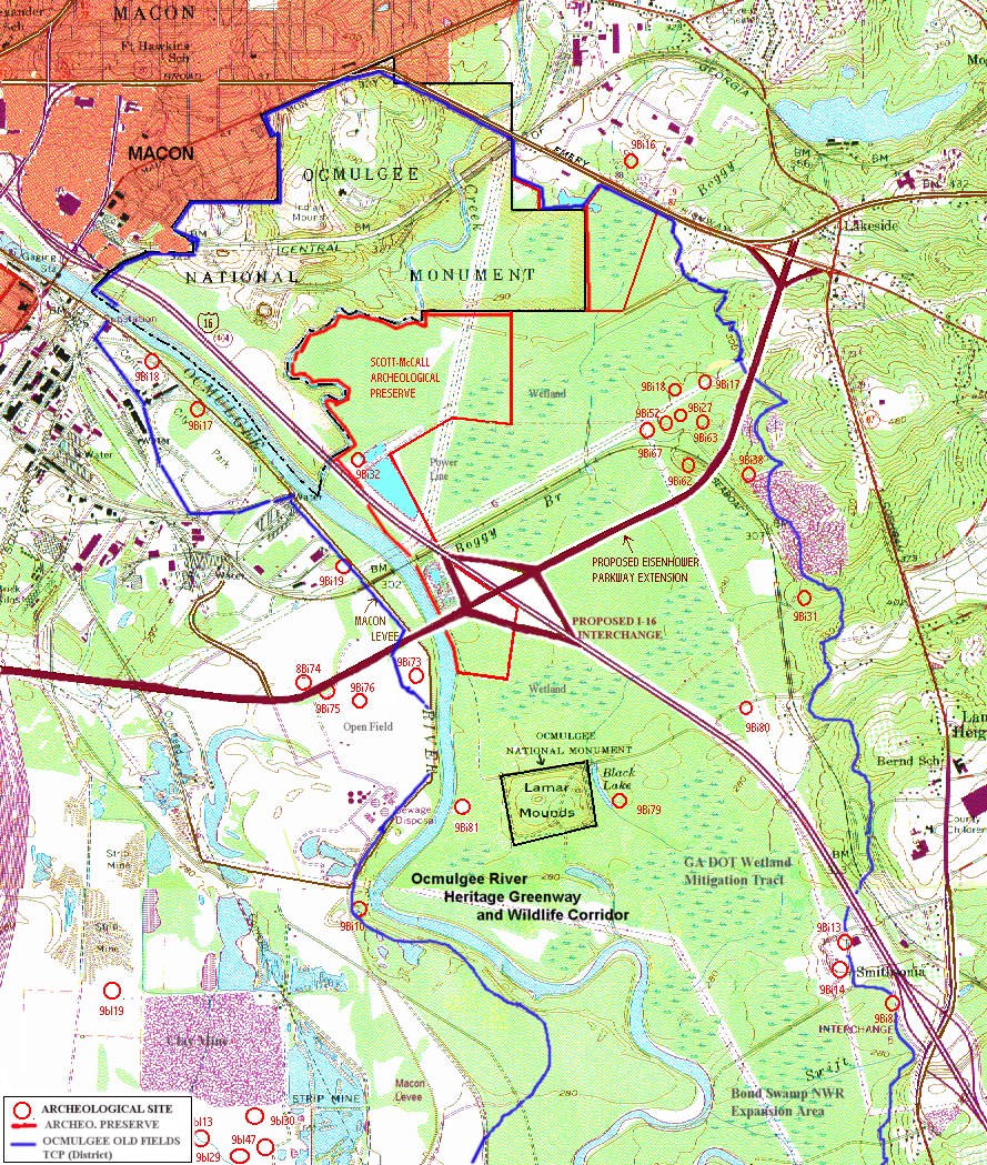
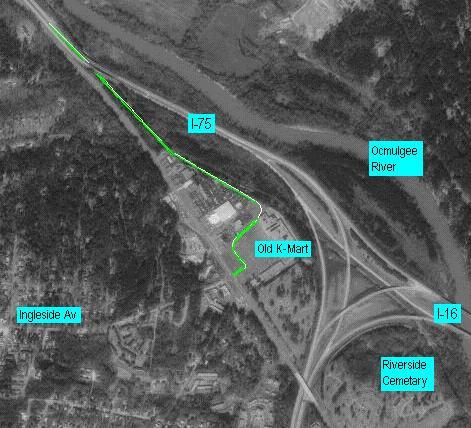
Plans to run a highway between the Indian mounds of Ocmulgee National Monument caused the National Parks Conservation Association on Monday to call Ocmulgee one of the 10 most-threatened national parks in the nation.

Ocmulgee takes its place among more well-known parks with problems, such as the Great Smoky Mountains National Park and its air pollution.

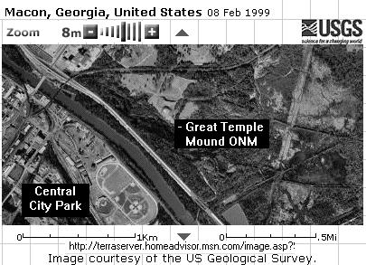
Ocmulgee preserves thousand-year-old Indian mounds, village sites and the mysterious Earth Lodge, a circular mound with a room and clay seats inside. The mounds are in two separate 
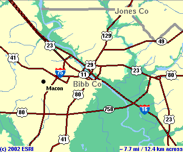
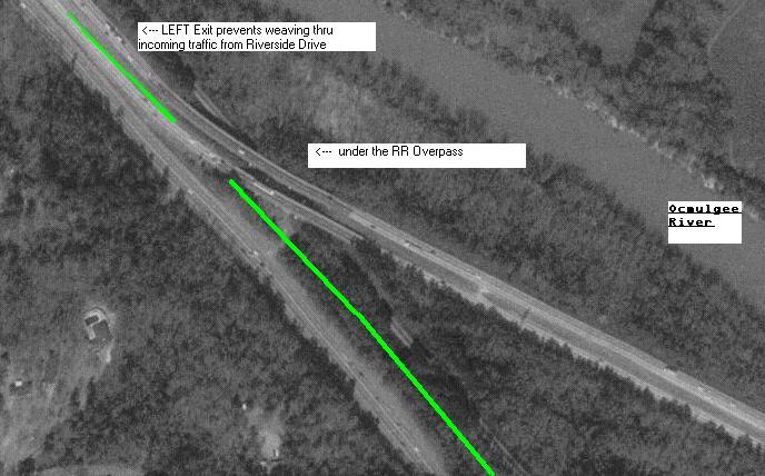
sections, and the state Department of Transportation is studying routing the Fall Line Freeway between the sections. The Fall Line Freeway will link Macon to Augusta and Columbus.

"We simply can't accept a four-lane highway passing just a stone's throw away from the national monument and straight through a piece of land with nationally significant artifacts, when other routes exist," said Jill Stephens with the park conservation group.

The undeveloped private land around the monument in Macon has a federal designation like that of a historic neighborhood because of its archaeological sites and the land's importance to the Muscogee Creek and other Indian nations.

Jim David, the superintendent of the monument, said there have been discussions about expanding the park. Common sense would dictate that the undeveloped land between the two sections, where the proposed highway would run, would be the best land to expand the monument, he said.

"Having a four-lane highway going through that would make that acquisition far less possible," David said.

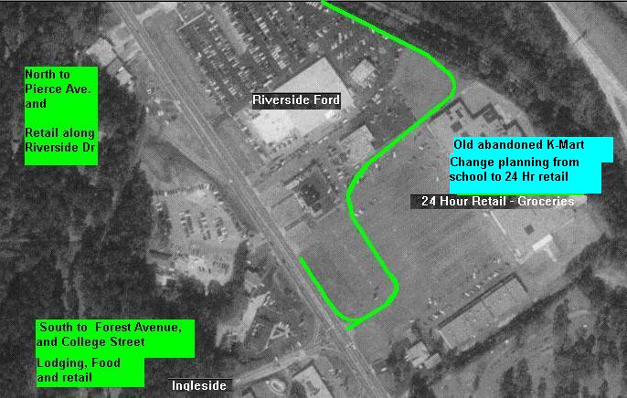
Advocates for the route, including local politicians and businessmen, say it is the only one that gives Macon traffic relief and brings needed development. Other proposed routes skirted the city.

The state DOT listed the route as a preferred alternative in earlier studies, which were rejected by the Federal Highway Administration. The FHWA said it looked like the state was writing its studies to justify the route, rather than to find the best route.

Vicki Gavalas, a spokeswoman for the state DOT, said the state did not write studies to justify the route. The new studies should be finished late this year.

Other national parks on the list: Great Smoky Mountains, Everglades/Big Cypress National Preserve, Federal Hall National Monument in New York, Glacier National Park, Glacier Bay National Park and Preserve, Mojave National Preserve, Valley Forge National Historical Park, Yellowstone and Big Bend.

http://www.accessatlanta.com/ajc/metro/0302/0326ocmulgee.html


The DOT "prefered route" has always been through the legislated boundaries of the Ocmulgee National Monument.

Proposed Penetration of ONM

Proponents of this "Prefered Route" insist that Columbus-Macon-Agusta can ONLY be connected for commercial traffic through the Eisenhower Parkway Extension.  

 Links:

 Maps near Ocmulgee Nat Monument

Images

http://terraserver.homeadvisor.msn.com/image.asp?S=13&T=1&X=160&Y=2272&Z=17&W=0

go to original image of above at TerraServer

Large color map showing environmental details 385Kb

Larger map of above 2.734 MB

 Alternative #1 is "No Build"  - using i16-i75  see below

Alternate route proposal sketch by Joeseph Passonnaeu

Caution Macon Rally at Bibb Courthouse see article

Another Caution Rally  and see  article

Walter Kulash with citizens  and article

CAUTION Macon Birthday Party

Sardis Church Road meeting 6-9-99 and article and pic

Interested Groups:

Friends of Ocmulgee Old Fields Homepage

National Trust for Historic Preservation

National Parks Conservation Association

Archaeological Conservancy

Sierra Club

Society for Georgia Archaeology

Georgia Indian Council and Native Americans across the country

Environmental Alliance for Central Georgia

Center for Law in the Public Interest

Citizens for Responsible Government- public policy foundation

CAUTION Macon    - homepage

Muscogee Creek Nation

Seminole Nation

Others

GaDOT

Moreland Altobelli

Bibb County

City of Macon

Capweb

 Macon Telegraph

Articles

Proposal to extend Eisenhower angers some 7-19-99

Road designers defend public (Silent-Deaf ) hearing policy

Bibb Chairman  backs away from citizen input  11-17-98

Fall Line Freeway at GA Hwy 96 1-12-00

Fall Line Freeway on move in Crawford-Peach 1-14-00

GRIP to cost 2.4 Billions

citizens' advisory committee should be heard 2-11-99

Ineffectiveness of Citizens Oversight Committee


i75-i16 Projects area map

http://www.i16i75.com

http://www.hollidaydental.com/caution/i75i16_proj.jpg

http://www.hollidaydental.com/caution/i75i16b_project.jpg

http://www.hollidaydental.com/caution/i75i16c_proj.jpg


this page is maintained by
  Lindsay 'Doc' Holliday  

Send Email

Holliday Dental Associates

360 Spring Street

Macon, GA 31201

office 478-746-5605

home 478-742-8699

Thank-You...