| Update articles in Macon Telegraph 9-10-09 |
||
| |
http://www.macon.com/local/story/838705.html
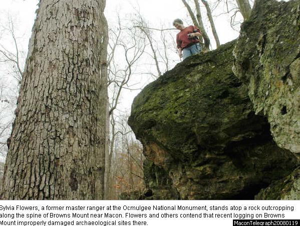
Thursday, Sep. 10, 2009 Brown’s Mount still closed, no opening in sight By S. Heather Duncan - hduncan@macon.com The new Bond Swamp comprehensive conservation plan doesn’t reflect the fact that Brown’s Mount is closed to the public, nor does it set a target date for reopening. That’s because problems that have kept Brown’s Mount closed arose after the planning process began, said Carolyn Johnson, assistant manager for Piedmont and Bond Swamp national wildlife refuges. Brown’s Mount is owned by the state but managed by the U.S. Fish and Wildlife Service as part of the Bond Swamp refuge. To head off a pine beetle infestation two years ago, the state arranged to cut a significant portion of the top of the rocky outcrop, which overlooks Bond Swamp. Afterward, state and refuge officials realized the logging operation seemed to have damaged an archaeological site dating to prehistoric times. Months later, as officials still struggled to set a time to meet and discuss how to correct the situation, a tornado struck the same area. Since then state and federal officials haven’t agreed on a solution, and the public has remained shut out. Johnson said the state archaeologist’s office hasn’t responded to a broad archaeological mitigation proposal submitted last summer by the regional archaeologist from the U.S. Fish and Wildlife Service. Now the service is putting together a much narrower proposal focused on clearing the trail and reopening it, Johnson said. Some Brown’s Mount supporters, who helped get the area preserved and donated to the Museum of Arts and Sciences in the 1990s, have criticized U.S. Fish and Wildlife’s management of the area, particularly the amount of time it has taken to resolve the logging damage. Bond Swamp’s comprehensive conservation plan, which is being finalized now, does call for a baseline archaeological survey and the creation of a “cultural resources management plan” by 2024. Johnson said there is no funding for protecting cultural resources on national wildlife refuges. The Telegraph archive contributed to this report. To contact writer S. Heather Duncan, call 744-4225. |
|
|
Story Comments:
youngdawg wrote on 09/10/2009 11:09:21 AM: My suggestion to anyone considering logging their land is to hire a local state-registered forestry consultant to ensure your best interest and intent are being represented. A forestry consultant will sit down with you to determine what your objectives are and will then convey those objectives to the logger. Next, a forestry consultant will ensure that these objectives are met through multiple unscheduled visits to the logging site during the harvest. Also, a forestry consultant will ensure that you are receiving top-dollar for your timber and that you are paid for all timber removed from your property. While hiring a forestry consultant will come at a fee, it will ensure that you are well represented and are not being hoodwinked. tfish wrote on 09/10/2009 10:18:05 AM: agreed kb1025. in the past, loggers cared for the woods, forests, swamps...they used wheel tractors, small skidders and chainsaws. they were more honorable back then. today, all loggers and timber companies care about is the almighty dollar. they rush in...tear the woods down...rush out. not caring about the woods, the land, the wildlife nor the landowner. don't get me wrong now..there are some good loggers out there, but they are few and far between. and they are a vanishing breed. ohhhhh! the almighty dollar....will be the death of this world. kb1025 wrote on 09/10/2009 07:35:21 AM: There are a lot of shady loggers out there. We hired one a few years ago to take down some pine trees and leave the very old oaks (1-2 foot diamiter) and dogwoods. They clearcut all the land and left all the oaks and dogwoods laying where they cut them; and completely ruined the land with their logging trucks and equipement. They disappeared in the night. They were out of Cochran. I would give their name, but that would probably cause this post to be removed (I understand why). Just be sure and always get a good contract with these guys before they cut, and make sure they are bonded, and have a good reputation. otherwiser wrote on 09/10/2009 01:22:13 AM: Ms Duncan, thanks for keepin us briefed on the Brown's Mount situation. |
||
|
||
| Thursday, Sep. 10, 2009
Bond Swamp readies for 20th anniversary By S. Heather Duncan - hduncan@macon.com http://www.macon.com/local/story/838725.html It was the middle of the morning, but beneath a leafy roof, Bond Swamp maintained its own twilight. Frequently scoured by flooding, the forest floor along Stone Creek was mostly open. But sounds seemed muffled by the thick moss and wet leaves speckled with fleshy orange mushrooms, unfurling like flowers. Bond Swamp National Wildlife Refuge celebrates its 20th anniversary next month, but there will be no party. The refuge remains a dark, quiet and little-known patch of wildness just a few miles from downtown Macon. But it is in the process of finalizing its first-ever comprehensive conservation plan, a hefty document that gives shape to the refuge’s future. The plan calls for geographic expansion, new programs and tours, boat access to Stone Creek and the Ocmulgee River, a new boardwalk trail, wildlife research, expanded hunting opportunities and more. But there’s no money attached to this vision. “The plan is what you want to do on the refuge,” said Carolyn Johnson, assistant manager for Piedmont and Bond Swamp national wildlife refuges. “If you got funding, this is what you’d do with it. Bond Swamp has never had its own budget. Hopefully, this plan will leverage that.” Bond Swamp includes more than 6,000 acres of land owned by the U.S. Fish and Wildlife Service, plus more than 1,000 additional acres, including Brown’s Mount, that is managed by the service through a lease agreement with the state. Together, the swath straddles the Ocmulgee River and surrounds a handful of private properties, where Bibb and Twiggs counties meet near Interstate 16. Many supporters say the refuge’s relative obscurity is related to its permanent lack of budget, office or staff. It is managed from Piedmont National Wildlife Refuge about 30 miles away. “Bond Swamp (as a wildlife refuge) took years to come to fruition, but it’s not really reaching its full potential because of the lack of management and funding,” said John Trussell, a Houston County resident who has hunted deer and wild hogs in Bond Swamp. Jerry Payne, a butterfly expert and Bond Swamp volunteer, was involved in the development of the new comprehensive plan for the refuge. He expressed frustration that the effort might be futile. “Let’s face it,” he said. “We’re in a recession and there’s only so many dollars. ... More access and more trails would be good, but it doesn’t do any good to ask for that because they have no funding.” He said if resources are limited, they should be directed toward protecting endangered red-cockaded woodpeckers at Piedmont National Wildlife Refuge rather than toward Bond Swamp. In tough economic times, the fish and wildlife service generally tries to maintain existing programs before starting new ones, which puts places such as Bond Swamp at a disadvantage for funding, Johnson said. A few years ago, the U.S. Fish and Wildlife Service announced that it was eliminating the only position at Piedmont that focused on Bond Swamp. After a year with the position empty, the service rescinded that decision, and someone has been hired to start in the job this fall. Plans would expand hunting, add access The refuge may have a low profile partly because access is limited. The refuge’s new plan, developed over two years with several public comment periods, could change some of that. It would add five full-time staffers to handle duties such as law enforcement, wildlife population monitoring and educational services for visitors. The plan calls for opening more of the refuge to hunting and adding turkey, waterfowl and small game to the list of species that can be hunted, Johnson said. Boat launches would be added along Stone Creek and at the Ocmulgee River. An access road would be added to the west side of the refuge, and turn lanes and road improvements would make entrances more accessible to school buses. “It definitely would be a huge asset to have a developed boat ramp there on the Ocmulgee River,” Trussell said. “It’s a beautiful section of river that’s little used.” Brian Adams, who owns Ocmulgee Expeditions, a canoe rental business, said he would certainly use it. He said several customers have also expressed interest in taking overnight trips into Bond Swamp. “The best way to see it is by boat,” he said. “It’s gorgeous and the tourism industry really needs to push it.” Adams and others believe that hunters are the only people allowed to canoe in the swamp. But Johnson said that actually changed a few years ago, and now there is a stretch of Stone Creek open to canoeing from March 15 to Oct. 15 during fishing season. ROUGH COSTS If all the new programs and initiatives in the Bond Swamp comprehensive conservation plan were implemented in the same year a highly unlikely scenario the first-year cost would be $7 million to $9 million, according to the draft conservation plan. Afterward, the changes would incur an annual cost of about $532,000. Once the conservation plan is approved, a series of more detailed plans will be developed under its umbrella, Johnson said. These will deal with issues such as suppressing wildfires, reducing invasive species and improving wildlife habitat. The plan envisions creating forest openings in the swamp to encourage migrating waterfowl such as endangered wood storks and surveying to learn more about reptile, amphibian, black bear and tree-dwelling bat populations. Ducks would be banded annually and boxes might be installed to encourage wood duck nesting among the teepee-shaped water tupelo trees, Johnson said. “The only thing we’ve been concerned about is whether they would promote wintering habitat for ducks,” said Bob Sargent, natural resources manager for Robins Air Force Base. “We can’t have numbers of wintering waterfowl that close to the airfield.” Andrew Hammond, refuge manager for Piedmont and Bond Swamp, said refuge officials would consult with the base before taking any steps that could grow the waterfowl population. One recent day, Johnson walked along Stone Creek, pointing out stands of cane 4 feet high and 5 feet wide. Cane thickets twice that height, with stems thick enough to be fishing poles, are needed to support Bond Swamp’s large nesting population of rare Swainson’s warblers. The migrant species is popular with birders. “One of the most reliable places to find it is in the cane thickets of Bond Swamp,” said Sargent, who is a member of the Ocmulgee Audubon Society. The conservation plan calls for removing selected trees to create light for these cane stands. An example of the effect is visible along the path where trees were toppled by last year’s Mother’s Day storms. Disks of roots and earth, each a dozen feet wide, stand on their sides, surrounded by clumps of new cane. The Stone Creek entrance to the refuge leads to a spot where a boat ramp is planned. Johnson said a take-out could also be added off Reid’s Station Road. Refuge officials would also like to add a canoe access at the Ocmulgee River, but the only place where the refuge owns a right-of-way is at the end of Bond Swamp Road. That road is practically falling into the river and would have to be shored up by the county, which has responsibility for it. The Stone Creek entrance also provides potential boardwalk destinations, such as an oxbow of the creek, where water pools after heavy rains. “In winter, you’d be standing at least waist deep in water here,” Johnson said after a hike through the woods. But with a boardwalk, “you could have an all-weather swamp experience,” she said. The refuge plan mentions adding more acreage but doesn’t go into details. In 1999, an expansion proposal established the “acquisition boundary,” an area where the refuge is approved to expand to the north, west and especially south. This additional territory includes portions of both Bibb and Twiggs counties, and it could overlap somewhat with the area where Bibb County is trying to discourage residential development for the sake of nearby Robins Air Force Base. “Conserving habitat and protecting it from future development will serve both Bibb County’s purpose and the Air Force’s,” Sargent said. “I think it’s great the Fish and Wildlife Service is forward thinking in looking to acquire more land for conservation.” Since its creation, the refuge has added 1,875 acres, including land owned by the state but managed as part of the refuge, Johnson said. But there are about 10,000 more potential acres identified in the acquisition boundary. The refuge is in the process of acquiring another portion using federal wetlands funds. Johnson said Piedmont officials don’t know the number of acres or the price yet. The service only buys from willing sellers, Johnson noted. Some of the land once within the acquisition boundary is no longer eligible for inclusion, she said. For example, a wetland forest on the west side of the refuge has since been turned into a three-phase subdivision. |
||
|
Eventually,
this trail is envisioned to be at least 22 miles long, extending from
Water Works Park to Brown’s Mount.
http://www.macon.com/local/story/787433.html Friday, Jul. 24, 2009 Ocmulgee Heritage Trail extensions to be added soon By S. Heather Duncan - hduncan@macon.com As Bragg Jam approaches, bringing with it the festival’s annual windfall for the Ocmulgee Heritage Trail, the trail is slated to extend farther in the coming weeks. A
contractor is expected to begin building a new 4,000-foot section of
trail along the top of the levee through Central City Park and south of
the park, said Mike Ford, CEO of NewTown Macon. NewTown administers the
trail.
|
||